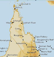
Presumably the fact that it is located at an airport gives it preferential treatment:
- 51 of the 103 stations (49.5%) in the RCS Network are located at airports or airstrips
- 11 of the 18 RCS stations (61.1%) in Queensland are located at airports or airstrips
- 60 of the 134 stations (44.8%) currently active in Queensland are located at airports or airstrips
The other seven stations in Peninsula District are:
027054 - Coconut Island - [data] [graph]
027058 - Horn Island - [data] [graph]
027073 - Coen Airport - [data] [graph]
027075 - Scherger RAAF - [data] [graph]
028004 - Palmerville - [data] [graph]
028007 - Musgrave - [data] [graph]
028008 - Lockhart River Airport - [data] [graph]
On the surface of it, Weipa Airport seems to meet none of the qualifications for a "high quality, long term" station.
1. It is sited next to an airstrip
2. It is missing most of its data
3. But for the few years that it has been collecting data, it does have a slight warming trend.
Of the remaining airport stations, five (027054 - Coconut Island, 027058 - Horn Island, 027073 - Coen Airport, 027075 - Scherger RAAF, 028004 - Palmerville) have less years of data than Weipa Airport, and are therefore less suitable candidates.
The sixth (028007 - Musgrave) has most of its data missing, and is therefore even less suitable.
028008 - Lockhart River Airport has far more years of data than Weipa Airport, but unfortunately it would seem to support a different narrative - namely 40 years of temperature stability:
By far the best candidate is the remaining non-airport station, 028004 - Palmerville. Its qualifications are:
1. Situated in a rural location, with no apparent contamination from human habitation or machinery:
2. A long term, almost complete set of data:
3. Unfortunately, like Lockhart River Airport, it also tells the wrong narrative - over a century of temperature stability:
Summary:
Weipa Airport could not be more untypical of the stations that the RCS claims to represent, namely "high quality, long term" records. The only two stations in this District which, on the surface of it, appear to more fully satisfy these requirments have been passed over - presumably because they support a different narrative. Unless there is another explanation, this would appear to be blatant cherry-picking of the worst kind. But then - why hasn't this been picked up by the "peer review"?


.png)


.png)